Nanaimo’s geology is a constant reminder that the subsurface rarely matches what’s drawn on a regional map. Glacial till, weathered sandstone, and pockets of marine clay sit side by side across the Harbour City, and the water table is often just a few feet below the surface in lower-lying areas near Departure Bay. This mix means that a standard borehole alone doesn’t always give the full picture. We use exploratory test pits to open a window into the ground, letting our geotechnical team log stratigraphy visually, collect undisturbed block samples from the Newcastle Formation colluvium, and spot seepage paths that rotary drilling can easily miss. When we combine the pit observations with a CPT test to capture continuous tip resistance and pore pressure data, the resulting ground model is far more reliable for foundation design in Nanaimo’s variable terrain.
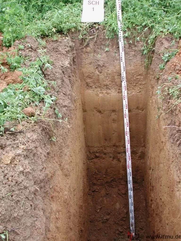
A test pit in Nanaimo’s glacial till isn’t just a hole in the ground—it’s a direct look at how water, clay lenses, and fractured sandstone interact at foundation depth.
Technical details of the service in Nanaimo
Risks and considerations in Nanaimo
A common observation we make on Nanaimo jobsites is that glacial lake sediments—thin, grey, and deceptively stiff when dry—turn into a near-liquid slurry the moment groundwater enters the pit. If this layer gets misinterpreted as competent till, the foundation ends up bearing on material that loses strength under saturation. We’ve seen this in subdivisions near Long Lake and along the Hammond Bay corridor, where the contact between the Vashon till and the underlying Quadra Sand creates a perched aquifer that nobody anticipated. An exploratory test pit catches this during the investigation phase. Skipping the pit and relying solely on SPT blow counts from a drill rig can mask the true behavior of these water-sensitive units, leading to differential settlement that shows up within the first two wet seasons.
Our services
Our exploratory test pit scope in Nanaimo covers the excavation, logging, sampling, and backfill—but the real value comes from the follow-up lab work and engineering correlation that turns field notes into design parameters.
Stratigraphic Logging and Sampling
Each pit is logged by a geotechnical engineer who maps unit boundaries, measures joint spacing in exposed sandstone, and collects bag or block samples for moisture content, Atterberg limits, and grain size analysis. We also install standpipe piezometers through the pit floor when the water table needs to be monitored over several tidal cycles in coastal Nanaimo.
Bearing Capacity Verification
For spread footings bearing on till or rock within the pit depth, we perform hand penetrometer tests and correlate visual classification with presumptive bearing values from the BC Building Code. When higher loads demand it, we coordinate a companion plate load test to confirm modulus of subgrade reaction directly at the excavation level.
Quick answers
What depth of exploratory test pit is practical in Nanaimo’s glacial soils?
With a mid-size track excavator, we routinely reach 4.0 to 4.3 meters in the Vashon till that covers much of central Nanaimo. Deeper than that, we hit the Quadra Sand or sandstone bedrock, and the pit becomes impractical for safety reasons—WorkSafeBC requires shoring or benching beyond 1.2 meters, and the cost of hydraulic shoring inside a narrow test pit quickly outweighs the benefit of going deeper.
How do you handle groundwater encountered during a test pit excavation?
We measure the inflow rate and the elevation where seepage first appears, then let the pit stand open long enough to observe whether the water stabilizes. If we need a permeability value, we run a rising-head or falling-head test right in the pit. On several Nanaimo projects near the Millstone River floodplain, this approach revealed a perched water table at 1.8 meters that the borehole logs had completely missed, and the foundation drains were redesigned before construction started.
What does an exploratory test pit cost in the Nanaimo area?
A single test pit program—mobilization, excavation, logging by a geotechnical engineer, sampling, and engineered backfill—typically falls between CA$790 and CA$1,020 per pit when we’re already on site for a broader investigation. The final number moves depending on access constraints, traffic control requirements on city streets, and whether we need to haul spoils off-site due to contaminated soil protocols.
Can you use test pits to verify bedrock depth for a retaining wall design?
Yes, and in Nanaimo this is one of the most cost-effective uses of an exploratory test pit. On sloped lots where a gravity retaining wall needs to key into sandstone, we excavate a pit directly at the proposed wall alignment to confirm the rock profile. When the bedrock surface is irregular—which is typical in the Wark Street and Brechin Hill areas—we use the pit data to adjust the wall step geometry before the concrete is poured, avoiding expensive change orders later.