The coastal climate of Nanaimo doesn’t just bring rain—it saturates the overburden and changes the game for any deep dig. When you’re cutting into the sandstone and shale bedrock that much of the city sits on, or working through the glacial till that blankets the slopes around Mount Benson, the margin for error shrinks quickly. The local geology, with its perched water tables and colluvium layers, demands a monitoring approach that catches deformation before it becomes a problem. Our team brings calibrated instrumentation to sites across Nanaimo, from the downtown core to the expanding subdivisions near Hammond Bay, tracking lateral displacement, piezometric levels, and vibration signatures so the excavation plan adapts to what the ground is actually doing. Combining this with a deep excavation design review ensures the support system matches the real-time behavior of the soil-structure interface.
Monitoring instrumentation transforms a static shoring design into a living document that responds to the ground’s actual behavior during excavation.
Technical details of the service in Nanaimo
Demonstration video
Risks and considerations in Nanaimo
The bedrock beneath Nanaimo is predominantly Cretaceous sandstone and shale of the Nanaimo Group, interbedded with coal seams that were mined extensively until the mid-20th century. This creates a genuine risk of encountering unmapped voids or fractured roof rock that can propagate upward as a chimney collapse during dewatering or vibration from compaction equipment. In the low-lying areas near the Nanaimo River estuary and along the Departure Bay shoreline, the water table sits barely two meters below grade, so any unmonitored cut quickly becomes a sump that destabilizes the face and undermines adjacent footings. Without continuous readout, a sudden pore pressure spike after a heavy rainfall event can go unnoticed until the shoring deflects beyond its serviceability limit. The monitoring program acts as an early detection system, flagging acceleration in displacement rates or anomalous piezometric response so the site team can adjust the dig sequence, increase dewatering, or install supplemental bracing before a minor anomaly becomes a costly repair.
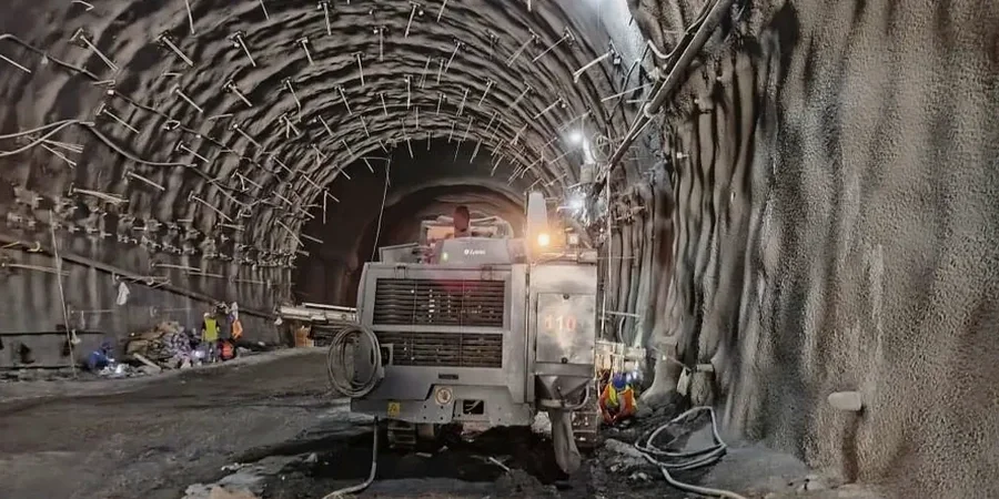
Our services
A monitoring program in Nanaimo is built around the specific failure mechanisms that the local geology presents. The following services form the core of a typical campaign, scaled to the depth, proximity to structures, and groundwater sensitivity of the site.
Inclinometer & ShapeArray Monitoring
Vertical and horizontal inclinometer strings or ShapeArray probes installed behind soldier pile and lagging walls to track shear band development in real time, with automated alerts for rate exceedance.
Vibration & Crack Monitoring
Triaxial geophones and displacement transducers placed on neighboring structures, calibrated to CSA S850 thresholds, with daily reports that correlate blast or compaction events to structural response.
Piezometric & Groundwater Surveillance
Vibrating wire and standpipe piezometers logging pore pressure fluctuations through tidal cycles and storm events, feeding into the dewatering plan to prevent base heave and piping.
Automated Optical Surveying
Robotic total stations tracking arrays of prisms on shoring, utilities, and building facades, delivering sub-millimeter displacement vectors updated every thirty minutes to the project dashboard.
Quick answers
What does geotechnical excavation monitoring cost for a typical Nanaimo hillside project?
A standard monitoring campaign for a single-family lot excavation with inclinometers, crack meters, and a few survey prisms over a two-month active dig phase typically runs between CA$1,280 and CA$3,900, depending on the number of instruments and the reporting frequency. Sites with deeper cuts, automated total station coverage, or longer monitoring durations will trend toward the upper end of that range.
How often are the instruments read during a Nanaimo excavation?
During active digging, key instruments like inclinometers and piezometers are read daily at minimum. Automated systems can push data every hour. After the excavation reaches final grade and the permanent structure is rising, the frequency drops to weekly or biweekly until backfilling is complete and readings have stabilized for two consecutive monitoring cycles.
What threshold triggers a stop-work order on a monitored site?
Thresholds are set during the pre-construction condition survey and depend on the fragility of adjacent structures. A typical trigger is a lateral displacement rate exceeding 5 mm per day at the shoring face, or a cumulative movement reaching 25 mm at a neighboring foundation. Vibration triggers follow CSA S850 limits, and any exceedance prompts an immediate review of the excavation method and a damage inspection of nearby buildings.