With an average elevation of 28 meters above sea level and neighborhoods carved into the foothills of Mount Benson, Nanaimo's topography presents constant geotechnical challenges. Our team approaches each slope stability analysis by first understanding the local overburden—a mix of Vashon till, Quadra sands, and colluvium that reacts dramatically to the region's 1,100 mm of annual rainfall. We don't just run models; we correlate field data from test pits with laboratory shear strength results to build a ground model that reflects what's actually beneath the surface. The 1946 Vancouver Island earthquake, which caused localized landslides in the region, serves as a reminder that pseudo-static loading must be integrated into any rigorous assessment on the island.
In Nanaimo's glacial terrain, ignoring the perched water table during a slope stability analysis is the single most common cause of post-construction failure we encounter.
Technical details of the service in Nanaimo
- Back-analysis of existing landslides using Spencer's method to calibrate residual strength parameters.
- Finite element modeling for complex geometries where bedrock topography creates kinematic constraints.
- Pseudo-static analysis per NBCC 2020 seismic hazard values for the Nanaimo area.
Risks and considerations in Nanaimo
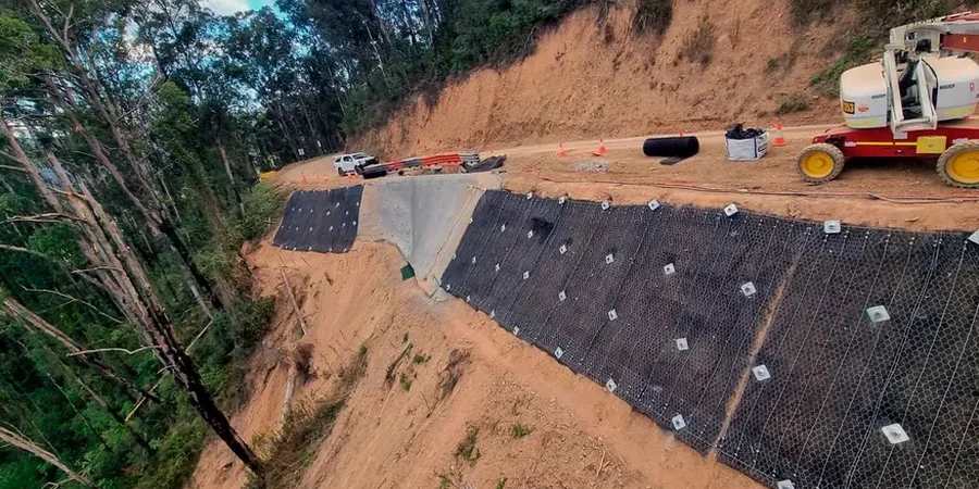
Nanaimo's expansion from a coal mining hub into a residential center has pushed development onto marginal lands, particularly along the steep bluffs overlooking the Strait of Georgia and the Nanaimo River valley. Many lots approved decades ago would not meet today's geotechnical scrutiny. The primary risk we identify is not deep-seated rotational failure but rather translational sliding along the till-bedrock interface, exacerbated by uncontrolled stormwater infiltration. When homeowners terrace their gardens without proper drainage, or when the city's winter storms deliver 100 mm of rain in 24 hours, pore-water pressures spike rapidly. A slope that stood for thirty years can fail in a single season if the toe is undercut or if a retaining wall is built without adequate weep holes. We've also observed progressive failure in the Newcastle shale slopes, where the material's fissility creates planes of weakness that daylight on road cuts along the Island Highway corridor.
Our services
Our scope for a Nanaimo slope stability project typically includes two integrated phases: a field investigation to characterize the subsurface, and an analytical phase to model failure mechanisms and design mitigation. We tailor the investigation to the specific geology of the site, whether it's the Quadra sands near Departure Bay or the till overburden in the south end.
Deterministic and Probabilistic Stability Modeling
We apply limit equilibrium software to calculate factor of safety for circular and non-circular slip surfaces, supplemented by probabilistic analysis when soil variability is high. This is essential for the heterogeneous colluvial deposits found in the Linley Valley and Chase River areas.
Remediation and Reinforcement Design
Beyond analysis, we specify practical stabilization measures: soil nailing for steep cut faces, horizontal drains to depress the water table, and mechanically stabilized earth berms. For deep-seated instability, we coordinate with structural engineers on tied-back soldier pile walls keyed into the Nanaimo Group bedrock.
Quick answers
What triggers a slope stability study in Nanaimo—is it only for new builds?
Not at all. While the District of Nanaimo requires a geotechnical assessment for any new construction on slopes steeper than 30% or within the Development Permit Area for hazardous lands, we also conduct studies for existing homes. Cracks in foundation walls, tilting retaining walls, or tension cracks appearing in the backyard after a heavy rain cycle are all common triggers that warrant a professional slope stability analysis.
Does the analysis consider the risk of earthquakes on Vancouver Island?
Absolutely. The NBCC 2020 assigns a significant seismic hazard to the Nanaimo region. Our pseudo-static analysis incorporates a horizontal acceleration coefficient derived from the site's PGA, typically in the range of 0.15 to 0.25 g for a 1-in-2,475-year event. For critical structures, we run full Newmark deformation analyses to estimate permanent seismic displacement, ensuring the slope doesn't just hold up but remains serviceable after a major earthquake.
How long does it take to get results from a slope stability analysis?
A typical timeline for a residential or small commercial property in Nanaimo ranges from three to five weeks. The field program—test pitting, drilling, and installing piezometers—takes about a week. The laboratory triaxial tests on undisturbed samples require two to three weeks to complete under consolidated-drained conditions. The analytical modeling and report drafting run concurrently, so we usually deliver the final stamped report within a month of mobilizing to site.
What's the typical cost range for a slope stability study in Nanaimo?
For a standard residential slope assessment in Nanaimo, the fee generally ranges from CA$1,900 to CA$5,880, depending on access constraints, the depth of bedrock, and the number of piezometers required. A complex commercial site requiring a drill rig, multiple inclinometers, and a full probabilistic analysis will fall at the upper end of that spectrum due to the increased field time and specialized laboratory testing involved.